You can now say you've officially had at least a week of below average, cold, snowy, icy, winter days. A week ago the high temp was in the 50s. Since then? Well, you know...
Now that we've been through a few days with snowfall, the forecast focus is quickly shifting to temperatures that may get low enough to bring on enhanced frostbite and hypothermia concerns.
Let's talk snow and then the temps...
SNOW vs. SUN
Yes, I said the other "s" word! We have chances to see the sun peeking through clouds on at least Thursday and Friday. It isn't a certainly, so don't get your hopes too high because I don't want you to be disappointed, BUT I do believe there is cause for hope. And if you do see that sun, I hope you'll send me a photo!
That said, we are still expecting light snow or flurries Wednesday night and Thursday morning. A dusting to an inch is possible for those who do see snow showers. Snow will still be fighting dry air overhead, but I do expect areas of snow to accumulate.
By midday Thursday areas mainly north of I-70 will have a chance to see some sun. (I know, I'm excited too! Remember, keep the expectations low...)
Friday will also be mostly cloudy but with the possibility for peeks of that giant light of burning gas in the sky.
Now, you might be thinking, "Kenton, you keep saying we might see the sun; that means it will be warmer, right?"
NO!
Actually if we do get any clearing it might make us even colder at night.
If we lose any cloud cover overnight then any "heat" trapped near the surface will escape and that will force our temps to plummet further. The snow covering the ground will only help in allowing for colder temperatures.
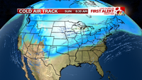
The other reason? A colder air mass of high pressure (another reason for the potential for sunshine) will actually have a big 'ol suitcase of arctic air with it. And it's going to open the suitcase this weekend. More on that next.
We do have weak chances for passing flurries or a brief snow shower on Saturday or Sunday, but at this time I am not overly concerned. Stay tuned for updates on this, we've got our eye on it.
More snow is possible starting Monday (President's Day) of next week.
DANGEROUSLY COLD
Am I hyping the situation when I talk about cold temperatures being dangerous? No.
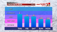
At times, wind chills will be so low that frostbite can form within 30 minutes. Moreover, hypothermia will be a threat for multiple day if folks aren't dressed properly or if they don't find heated shelter.
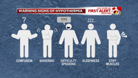
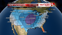
The cold air mass with arctic air I mentioned above will push in this weekend. Morning lows will be in the single digits and afternoon highs will only reach the teens... for Thursday and Friday. It will get worse from there.
Saturday, Sunday, and Monday are expected to be the coldest days we've had in over two years and the longest stretch of these brutal temps in at least three years, if not longer.
Temperatures over these three days will likely be in the single digits and negative single digits for 72+ hours... and wind chills will likely hold below zero the entire time. Yes, that is dangerously cold.
Now, if there is a shift in this area of arctic air, we may be warmer, but for now that is not the case and you should prepare for these cold temperatures accordingly.
The mornings of Sunday, Monday and Tuesday are expected to have wind chills between -15 and -20º. In these conditions frostbite can form in as little as 30 minutes. Cover exposed skin and dress in layers to protect yourself from frostbite and hypothermia.
You'll also want to leave your sink doors open and maybe even have a slight drip from faucets to keep water moving very slowly and keep the pipes warm. You don't want any pipes to freeze due to temperatures being so cold for so long.
LOOKING AHEAD
Next week features chances for snow and a very very very slow "warming" trend.
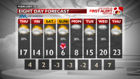
We'll remain below average in temperatures through at least the middle of February. In fact, we're still more than a week away from when we might get back above the freezing line again. The first chance for that doesn't arrive until next weekend, around February 20th.

LOOKING BACK
The main cold temperature record we're watching closely is on Sunday, February 14. This year, I expect us to smash the previous record by more than ten degrees.
2021 may be the second year in a row when the coldest day of winter is on Valentine's Day.
Coldest Temps Over The Past 10 Years
| YEAR | DAY | LOW TEMP |
|---|---|---|
| 2020 | Feb. 14 | 0º |
| 2019 | Jan. 3 | -7º |
| 2018 | Jan. 1 | -9º |
| 2017 | Jan. 7 | 0º |
| 2016 | Jan. 18 | 0º |
| 2015 | Jan. 8 | 0º |
| 2014 | Jan. 6 & 7 | -11 |
| 2013 | Feb. 1 | 6º |
| 2012 | Jan. 18 | 9º |
| 2011 | Feb. 3 & 10 | -10º |
"in" - Google News
February 11, 2021 at 10:15AM
https://ift.tt/3pdUNUS
Forecast: Dangerously cold temperatures move in this weekend - KOMU 8
"in" - Google News
https://ift.tt/2MLa3Y1
https://ift.tt/2YrnuUx
Bagikan Berita Ini


0 Response to "Forecast: Dangerously cold temperatures move in this weekend - KOMU 8"
Post a Comment