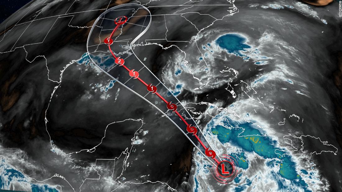
(CNN)Tropical Storm Ida has formed in the Caribbean Sea and confidence is growing that a potentially major hurricane could hit the United States by late this weekend or early next week.
Exactly where and when is still to be determined, with these details expected to come into better focus once the center of the system is located, perhaps later Thursday.
"The center of the [storm] will pass near of over the Cayman Islands tonight, the Isle of Youth and Western Cuba Friday, and move over the southeastern and central Gulf of Mexico on Friday night and Saturday," the National Hurricane Center said.
At 5 p.m. ET, the storm was about 100 miles west of Negril, Jamaica. It had maximum sustained winds of 40 mph.
The system is forecast to approach the northern Gulf Coast of the US on Sunday, the NHC said.
Tropical storm warnings are in effect for the Cayman Islands and western Cuba. A tropical storm warning means that tropical storm conditions are expected somewhere within the warning area within 36 hours.
Steady strengthening is forecast during the next few days and the system is expected to become a tropical storm Thursday night.
"(Computer forecast) models overall have increased in agreement with the track, focusing on the northern Texas coast and the coast of Louisiana," the National Weather Service in Lake Charles, Louisiana, said Thursday. Compare the 2 main forecast models here
Louisiana Gov. John Bel Edwards declared a state of emergency Thursday due to the potential impacts and further development of Tropical Storm Ida.
"Unfortunately, all of Louisiana's coastline is currently in the forecast cone for Tropical Storm Ida, which is strengthening and could come ashore in Louisiana as a major hurricane as Gulf conditions are conducive for rapid intensification. Now is the time for people to finalize their emergency game plan, which should take into account the ongoing COVID-19 pandemic," Edwards said in a statement.
Where there is high confidence
The environmental conditions are ripe for tropical cyclone development, so the possibility that this system will strengthen into a hurricane is high.
"Once the system moves into the Gulf of Mexico, conditions are expected to be conducive for additional strengthening, and rapid intensification is explicitly shown in the NHC forecast between 48 and 72 hours," the NHC said.
"The NHC intensity forecast brings the system near major hurricane strength when it approaches the northern Gulf coast on Sunday."
"As a result of this forecast and agreement of strengthening amongst computer forecast models, there is higher-than-normal confidence that a strengthening tropical cyclone will be moving over the Gulf this weekend."
Where there is less confidence
"This system is forecast to approach the northern Gulf Coast at or near major hurricane intensity on Sunday, although the forecast uncertainty is larger than usual since the system is just forming," said the NHC.
Unfortunately, there still remains a fair amount of uncertainty in the exact track with the cluster of thunderstorms. Computer forecast models and the current thinking from the NHC bring the storm anywhere from eastern Texas to eastern Louisiana.
One reason for the uncertainty is how strong an area of high pressure is in the atmosphere's upper levels.
This high pressure is what will help steer the direction of any hurricane that does form, the National Weather Service in Houston explains. If the high is stronger or further west, the storm will be guided further west toward Texas. If the high is weaker or further east, the storm will follow suit and slide eastward toward Louisiana.
The other big factor hampering the track forecast confidence is where exactly the storm will form a center of circulation. Right now, it is just a cluster of thunderstorms with no center of circulation.
"Some shifts in the track are likely until the system consolidates and becomes better defined," said the NHC.
Why finding the center matters
Finding the center of circulation should improve the forecasts.
"The computer forecast models extrapolate out a low pressure's center position through time," CNN meteorologist Chad Myers said.
"The computer forecast models extrapolate out a low pressure's center position through time," CNN meteorologist Chad Myers said.
"Without knowing exactly where or how strong a storm is from the beginning, the final position and strength can be, at times, wildly inaccurate."
If the center is misplaced by 25 miles from the beginning, the three-day forecast can be off by a hundred miles or more, said Myers.
The data going into the models is the best guess at where the center is located. By Thursday evening, an aircraft will fly out to investigate the disturbance in the Caribbean. When it does, it will provide pivotal data that will be ingested into the models.
That will likely give meteorologists a much clearer picture of where the storm will go, when it will get there and how strong it will be.
Either way, "there is a risk of life-threatening storm surge, damaging hurricane-force winds, and heavy rainfall Sunday and Monday along the northern Gulf Coast from the Florida Panhandle to the upper Texas coast, with the greatest risk along the coast of Louisiana," the NHC warned.
"in" - Google News
August 27, 2021 at 07:03AM
https://ift.tt/3kpfP2E
Tropical Storm Ida forms in the Caribbean, could hit US as a hurricane - CNN
"in" - Google News
https://ift.tt/2MLa3Y1
https://ift.tt/2YrnuUx
Bagikan Berita Ini


0 Response to "Tropical Storm Ida forms in the Caribbean, could hit US as a hurricane - CNN"
Post a Comment